
Common Operating Picture

TWO BLIND SPOTS

Scattered information and information that doesn't exist yet

EVERYTHING YOU ALREADY OWN

Calls, records, cameras, plate reads, sensors and units, on one map.

EVERYTHING IN THE AIR

Airborne detection sources, brought onto the same map as everything else.

Everything in the air. Everything you already own.
One map.

IN THE AIRRemote ID broadcastsADS-BRadar · RF · EO/IR · AcousticCooperative and non-cooperative sourcesEVERYTHING YOU ALREADY OWNCAD / 911Records managementCameras — any systemCamera registry, with ownersPlate readsUnits · Alarms · SensorsONE LAYERairborne trackcameraactive callunitplate readsensor alertOne operating picture

Two blind spots, and they are not the same problem

On the ground, the information exists and it is scattered. Dispatch has the call. The supervisor has the camera. The plate read is in a vendor's portal. The units on scene have whichever of those someone had time to say out loud. Nothing is missing — it is just in five places.


In the air, the information mostly does not exist yet. A drone over a yard, a stadium or a beach event arrives as a phone call from a person who looked up. Agencies that have bought a detection sensor have usually bought a second screen along with it.


A common operating picture is supposed to solve the first problem. Buying an airspace tool that stands alone recreates it.
ON THE GROUND — SCATTEREDCAD / 911CameraPlate readRecordsUnitsNothing is missing. It is in five places.IN THE AIR — MOSTLY ABSENT?????a phone call fromsomeone who looked upThe information mostly does not exist yet.
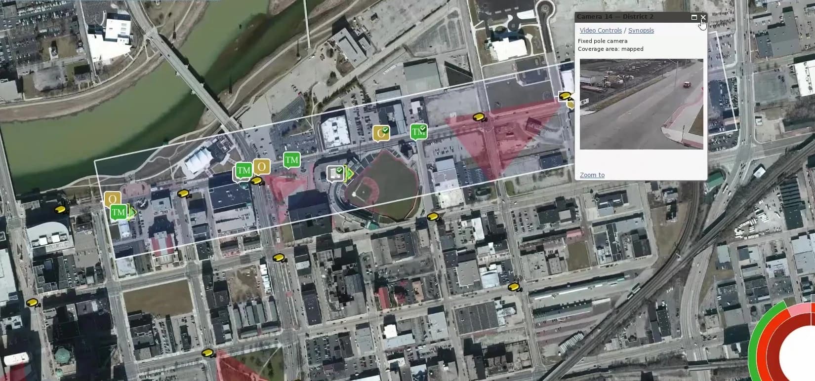
Footprint map showing mapped cameras, monitor zones and a live camera preview across a city district

Everything you already own

Footprint runs over the systems your agency has already bought. No forklift upgrade, no standardizing on one supplier, no retiring equipment that works.

  • Calls and records. CAD/911 and records-management data on the map at the location it belongs to.
  • Cameras. Live and recorded feeds from the systems you already run — city-owned, private partner, fixed or mobile — shown at the point on the map the camera actually covers.
  • Every camera, mapped. Public and private cameras plotted with owner and contact information attached, so you know who to call. Owners can register their own.
  • Plate reads. In the same view as everything else, not in a separate portal.
  • Sensor and alarm feeds. Gunshot detection, connected sensors and panic alerts, on the same map as the units responding to them.
  • Units. Where your people are, alongside what they are responding to.
  • Heat maps put past and present side by side, on a National Incident-Based Reporting System foundation. The platform organizes the data; the call is yours.

Everything in the air

The same principle, one domain up. Footprint is being built to bring airborne detection sources onto the same operational map as everything else.


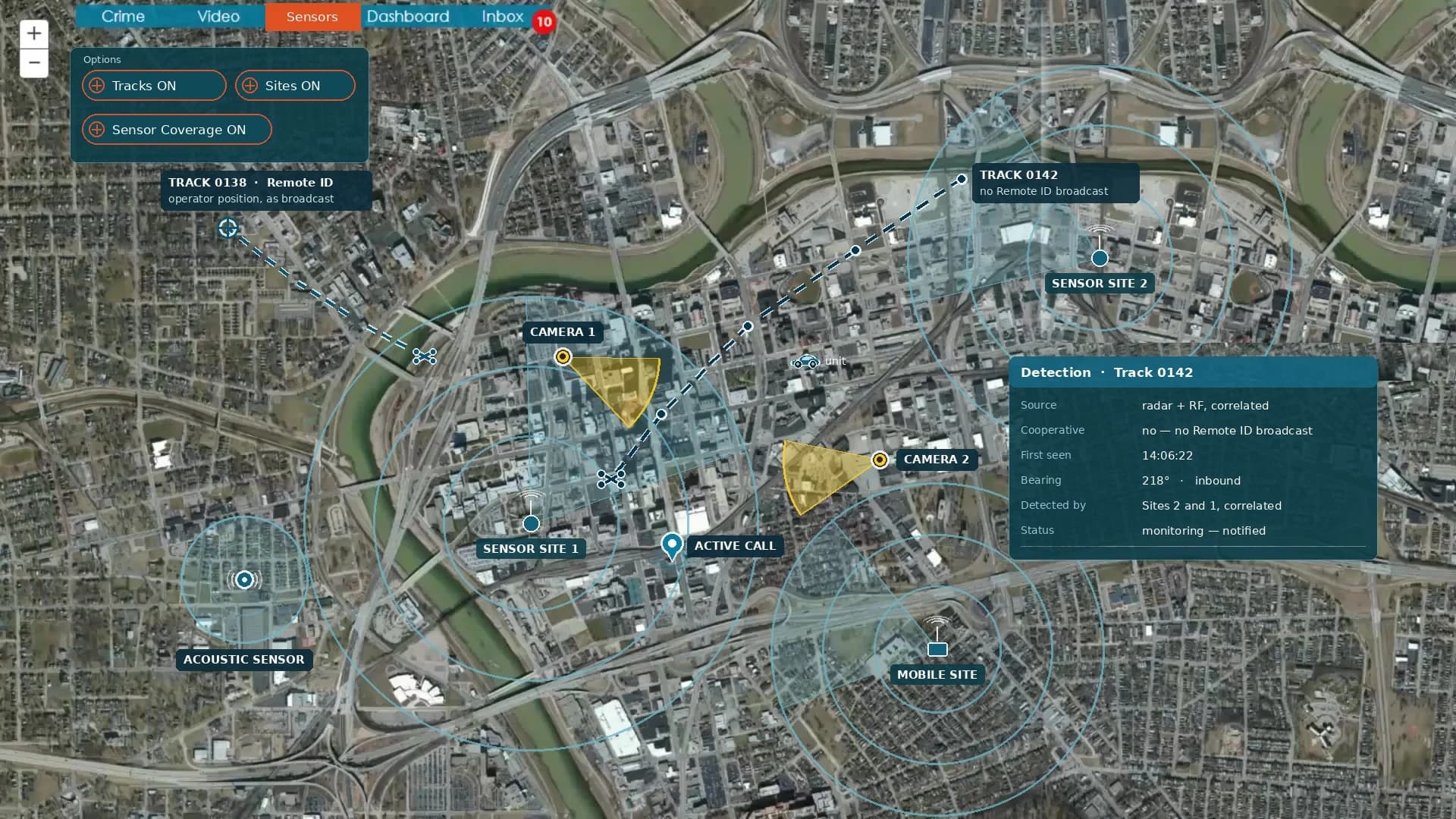
  • Cooperative traffic. Remote ID broadcasts and ADS-B, so the aircraft that are announcing themselves appear where they are.
  • Non-cooperative detection. Radar, RF, electro-optical and infrared, and acoustic sources — the sensors that see what is not announcing itself. Source-agnostic and aligned to open sensor architecture standards.
  • On the map with everything else. The track, the units, the nearby cameras, the call that came in — one picture rather than a radio conversation between three systems.

A drone is not an airspace problem. It is an incident. The deputies responding to it are on the ground. The cameras that might catch the operator standing in a parking lot are on the ground. The call that reported it came through dispatch. The pattern that tells you it is the fourth time this month is in your records. Put the air on its own screen and someone has to hold both pictures in their head, out loud, over the radio, while it is still happening.

Cooperative and non-cooperative airborne detection sources brought onto the operational map with all your data and sensors